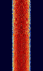
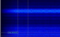
Inmarsat-C TDM
 | |
|---|---|
| Frequencies | 1537.7 MHz,1539.585 MHz,1539.685 MHz,1539.525 MHz,1539.555 MHz |
| Frequency Range | 1537.7 MHz - 1539.685 MHz |
| Mode | USB |
| Modulation | PSK |
| ACF | 135 ms |
| Emission Designator | — |
| Bandwidth | 2.5 kHz |
| Location | Worldwide |
| Short Description | Inmarsat C provides two-way data and messaging communication services to and from virtually anywhere in the world. The low-cost terminals and antennas are small enough to be fitted to any size of ship. |
| I/Q Raw Recording | Download file |
| Audio Sample | |
|
This signal identification is from Inmarsat 3-F4. This is a 1200 bpsBits per second (bps) DBPSK Network Control Station Channel (NCSC).
The Inmarsat C maritime mobile satellite system has an inherent capability, known as Enhanced Group Call (EGC), which allows broadcast messages to be made to selected groups of ship stations located anywhere within a satellite's coverage. Four geostationary satellites provide worldwide coverage for these types of broadcasts. Two types of EGC services are available: Safety NET and Fleet NET. Fleet NET is a commercial messaging services offered by Inmarsat, and is not recognized by the Global Maritime Distress & Safety System, or GMDSS. Safety NET, along with NAVTEX, is recognized by the GMDSS as the primary means for disseminating maritime safety information. Ships regulated by the Safety of Life at Sea Convention travelling outside areas covered by NAVTEX must carry an Inmarsat C Safety NET receiver by 1 February 1999.
Samples[edit]
Frequencies[edit]
Check UHF Satcom for frequencies.
For the TDM NCSC channels, they are fixed for the following Ocean Regions (OR):
AOR-W: 1537.70 MHzMegaHertz (MHz) 10^6 Hz
IOR: 1537.10 MHzMegaHertz (MHz) 10^6 Hz
AOR-E: 1541.45 MHzMegaHertz (MHz) 10^6 Hz
POR: 1541.45 MHzMegaHertz (MHz) 10^6 Hz
View This map to see what each ocean region used to cover in 2015. Use a sat tracker (e.g. G-Predict) and look for birds in geostationary orbit (zero inclination; not changing longitude) to find the (likely) currently operating satellites. The ORs maybe inferred from the 4 main ground footprints.
Decoding Tutorials[edit]
Decoding Software[edit]
- Hobby Level Software
- Professional Equipment/Software


