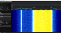
GOES High Rate Information Transmission (HRIT)
From Signal Identification Wiki
 | |
|---|---|
| Frequencies | 1694.1 MHz |
| Frequency Range | 1694.1 MHz - 1694.1 MHz |
| Mode | RAW |
| Modulation | BPSK |
| ACF | — |
| Emission Designator | — |
| Bandwidth | 1.205 MHz |
| Location | Worldwide |
| Short Description | GOES HRIT is a retransmission of satellite imagery and other information from the GOES-R series of satellites. |
| I/Q Raw Recording | Download file |
| Audio Sample | — |
GOES HRIT is a retransmission of satellite imagery and other information from the GOES-R series of satellites. It is possible to decode it and get images with cheap hardware.
Frequencies[edit]
1694.1 MHzMegaHertz (MHz) 10^6 Hz, it is the same for all GOES-R satellites.
Decoding Software[edit]
Decoding Tutorials[edit]
https://pietern.github.io/goestools/guides/minimal_receiver.html
https://lucasteske.dev/2016/10/goes-satellite-hunt-part-1-antenna-system/
http://www.prutchi.com/2019/07/11/receiving-emwin-and-hrit-services-from-goes-16-with-xrit/
Additional pictures[edit]
|
|
