CORIOLIS Tactical Direct Broadcast
The CORIOLIS Tactical Direct Broadcast link carries direct broadcast (real time) data from the CORIOLIS satellite (a satellite designed to measure sea waves, and indirectly, wind speed and direction).
Satellite payload[edit]
The primary payload of CORIOLIS is WindSat, an instrument that uses several microwave sounders with different polarization and frequencies, to detect and measure sea waves, their height, period and direction. With further processing, it is then possible to extrapolate wind speed and direction based on the waves' behavior. Additionally, it is possible to use the high-GHzGigaHertz (GHz) 10^9 Hz channels to detect water vapor absorption (such as cloud and precipitation), although this is not the instrument's primary purpose.
Signal characteristics[edit]
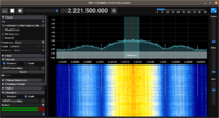
The signal is transmitted in the S band at 2221.5 MHzMegaHertz (MHz) 10^6 Hz. It is called 'Tactical' as it was meant for field use by the U.S. Navy, and therefore the power of the link is increased compared to typical S band links.
The modulation used is BPSKBinary Phase-Shift Keying (1 bit per symbol), the data format uses CCSDS encoding with a convolution rate of 1/2 and Viterbi FECForward Error Correction.
Baseband recording[edit]
- Five seconds of CORIOLIS Tactical DB signal, captured using a RTL-SDR, a MMDS downconverter at 2.4 MHzMegaHertz (MHz) 10^6 Hz of bandwidth.


